Canadian postal code polygons are more than just map features. They are key geospatial units used in many industries. These include logistics, urban planning, retail site selection, and disaster response. Aeroview’s postal code polygons are designed to work well with GIS workflows. They help solve real business problems where detail, accuracy, and up-to-date information are important.
Download sample polygon files here.
Geospatial precision is the new business currency: Postal code polygons delineate the precise geographic boundaries associated with the six-character alphanumeric postal codes maintained by Canada Post. Sophisticated enterprises use this data to:
- Drive advanced market analysis and demographic segmentation;
- Optimize multi-modal logistics routing with boundary-accurate targeting;
- Oversee compliance zones and service-area restrictions;
- Enrich customer datasets for hyper-local analytics.
Modern GIS integration: You can easily overlay spatial datasets like shapefiles or GeoJSON with enterprise data. This helps make strategic decisions in real time.
What Are Canada Postal Code Polygons?
Canada Postal Code Polygons define geographic areas covered by postal codes. Each polygon corresponds to a specific postal code region. They are created based on factors like population density and geographic features.
These polygons are essential in many fields. In GIS, they enhance mapping and analysis. Businesses utilize them for market analysis and demographic studies. They pinpoint locations with precision, offer a structured approach to spatial data management. This allows for comprehensive geographic analyses.
The Structure of Postal Codes in Canada
Canadian postal codes are grouped into Forward Sortation Areas (FSA) and Local Delivery Units (LDU). This helps with both large and small-scale spatial analysis. At Aeroview, we create polygons using standard GIS methods. We cross-reference Canada Post’s monthly and yearly data. We also include topographic, street, and municipal datasets to improve spatial relationships.
Each postal code consists of six alphanumeric characters. This format helps in organizing areas efficiently.
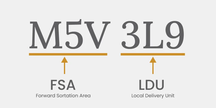
The first character denotes a specific region within the country. The remaining characters help narrow down exact locations. This precision assists in various applications.
Understanding this structure is essential for several reasons:
- Facilitates efficient mail delivery.
- Enhances data accuracy in location-based services.
- Supports detailed spatial analysis.
The structured system aids in managing and analyzing vast geographical areas. This is crucial for both businesses and public services. It ensures effective coverage and service delivery throughout Canada.
How Postal Code Polygons Are Created
Creating Canada Postal Code Polygons involves detailed geographic processing. The process begins by collecting accurate postal code data from Canada Post. This data serves as a foundation for mapping the postal code regions.
Spatial data is then applied to define boundaries. Geographic Information Systems (GIS) play a key role. They process and visualize the polygon shapes, aligning them with real-world locations.
Key steps in creating these polygons include:
- Collecting postal code data
- Using GIS tools for boundary definition
- Validating with geographic features
Through GIS, these polygons achieve precision and scalability. They become useful tools for comprehensive spatial analysis. Understanding their creation helps in leveraging their potential effectively.
Why and How Postal Code Boundaries Change
The Nature of Change
Postal code boundaries in Canada are continuously updated due to a confluence of factors:
- Urban Expansion: Fast growth in cities and suburbs needs new postal codes. We also need to change old ones. This helps with mail delivery and matches population changes.
- New Infrastructure: Road construction and the addition of new neighborhoods or commercial districts frequently necessitate boundary changes to accommodate shifting delivery logistics.
- Administrative Reorganization: Municipalities sometimes restructure postal code areas to optimize delivery routes or reflect new governance boundaries.
- Community and Stakeholder Input: Sometimes, boundary changes happen because residents or businesses ask for them. They want clearer identities, better real estate value, or easier logistics.
Update Frequency
- Continuous Micro-updates: Canada Post introduces postal code changes on an ongoing, monthly basis. These changes include new postal codes, revisions, and retirements.
- Major Dataset Releases: Comprehensive postal code polygon datasets are typically updated and released on a monthly basis by leading providers; authoritative geospatial products, such as the Postal Code Conversion File (PCCF), are refreshed in alignment with each national census—a five-year cadence for boundary realignment to census geographies.
- Scale of Change: In 2022, for example, Canada saw over 4,500 postal code changes—underscoring the importance of up-to-date datasets for spatial accuracy and operational reliability.
Using a vendor like Aeroview ensures you get the freshest and most accurate postal code polygons. This is important for keeping data reliable in business operations.
Key Applications of Canadian Postal Code Polygons
Canada Postal Code Polygons have applications across various sectors. Businesses use them to gain insights into market demographics, improving target marketing strategies. They enable businesses to pinpoint areas with potential customers efficiently.
In logistics and delivery services, these polygons are indispensable. They assist in optimizing delivery routes, thus saving time and reducing costs. Postal code polygons ensure that logistics operations run smoothly and efficiently.
They are crucial in emergency management too. Agencies use postal code polygons to allocate resources during natural disasters or emergencies. By knowing exact locations, responses become quicker and more precise.
Key applications include:
- Market analysis and segmentation
- Route optimization for logistics
- Emergency resource allocation
Additionally, postal code polygons aid in urban planning and environmental assessments. They help planners assess population impacts and resource distribution. Leveraging these polygons supports informed decision-making across numerous domains.
Using Postal Code Polygons in GIS and Business
Postal code polygons offer distinct benefits for businesses and GIS projects. They enhance data accuracy, ensuring that decisions are based on precise spatial information. This precision supports more effective business strategies and analyses.
In the business realm, postal code polygons streamline operations by providing valuable insights. They help identify new market areas and optimize service delivery. Companies can allocate resources more effectively, thanks to geospatial precision.
Key benefits include:
- Improved decision-making with accurate data
- Enhanced resource allocation
- Identification of new market opportunities
Geographic Information Systems (GIS) professionals also benefit greatly. They use postal code polygons to integrate data layers efficiently. This integration leads to comprehensive and detailed spatial analyses, critical for making informed decisions.
Enterprise Use Cases: From Theory to ROI
- National retailers leverage postal code polygons for location analytics to optimize site selection and local marketing.
- Logistics firms route deliveries by polygon boundaries to enhance last-mile efficiency.
- Insurance and financial institutions conduct risk assessments and fraud analysis with granular geographic overlays.
- Utilities & Telecoms use them to align service territories and meet regulatory requirements.
Challenges and Considerations
Using Canada postal code polygons comes with some challenges. Accuracy and regular updates are crucial for maintaining data integrity. Rapid urban development often leads to changes in postal code boundaries.
Regular updates and meticulous spatial validation are non-negotiable for business-critical applications. Rapid regional growth, integration of disparate datasets, and evolving privacy regulations demand a robust, standards-focused approach to data management.
- Aeroview Advantage: Our polygons undergo rigorous quality assurance, with ongoing synchronization to Canada Post and census geographies. Aeroview offers high-quality postal code datasets with flexible licensing.
Data integration also presents issues. Ensuring consistency between different datasets can be complex. Additionally, privacy concerns arise when using location data.
Consider these challenges:
- Accuracy and updates
- Data integration complexity
- Privacy concerns
Being aware of these challenges helps in making informed decisions. Thoughtful planning and careful data handling can mitigate potential drawbacks.
Future Outlook: Toward Real-Time Geospatial Intelligence
With the convergence of AI, IoT, and distributed cloud systems, the future of postal code polygon analytics is real-time, predictive, and integrative—enabling not just location analysis, but location intelligence.
Conclusion
For B2B professionals in logistics, urban systems, site planning, or data science, accurate Canadian postal code polygons are important. These tools help in various tasks and decision-making processes. Working with Aeroview makes sure your geospatial analysis uses the best and latest polygon boundaries.
For technical specifications, licensing, or to schedule a data sample, contact the Aeroview geospatial team for consultation.
If you’re seeking to map postal codes Canada for market analysis, logistics, or business expansion, Aeroview Technologies Inc. offers comprehensive solutions. Our datasets include fsaldu details, zip code polygon data, and highly accurate canada postal code maps for all regions. We provide postcode shapefile formats and geo postal code resources tailored to your project’s needs. Leverage our canada postal code latitude longitude database to enhance location intelligence and deliver superior results. Contact us today for reliable zip code shapefiles and detailed mapping support.
Aeroview Technologies Inc. can deliver custom canada postcode map products and a full canadian zip code map for your organization. Whether you require fsa ldu breakdowns or robust postal code mapping capabilities, we can supply canadian zip codes map products and enable you to work with a granular map of postal codes in Canada. Ask us about our zip code polygon database and data on zip code regions for advanced postal code mapping Canada. Empower your operations with a modern canadian postal code map—reach out to Aeroview for expert geospatial support.