A Mexico address file can look complete in a spreadsheet and still fail when it reaches a routing engine, geocoder or enterprise database. The difficult questions begin after the row count: Does each record represent a real premise? Is the coordinate tied to a building, entrance, parcel or street? Are street names normalized consistently? How are interior units handled? When was the dataset last updated?
For logistics, digital mapping, insurance, telecommunications and location analytics, those distinctions determine whether an address database becomes dependable operational infrastructure or another source of exceptions.
Why Mexico address data is not one simple national file
Mexico has strong national reference systems, but they serve different purposes. Correos de México maintains the national postal-code catalogue. INEGI’s Marco Geoestadístico provides geographic reference layers such as states, municipalities, localities, blocks, block faces and roads. Mexico also has a national technical standard describing the components of a structured geographic address.
These resources are essential, but they should not be mistaken for a production-ready national address-point product. An enterprise address layer must connect written address components to usable coordinates, resolve inconsistencies across sources, distinguish physical premises from postal or administrative records and present the result in a stable schema.
That is why two vendors can both claim “Mexico coverage” while delivering very different products.
Address points, postal codes and geocodes answer different questions
A postal code identifies a delivery zone or postal reference. It is valuable for sorting, regional analysis and many customer-data workflows, but it does not identify the exact location of every property.
A geocode is the coordinate returned after an address is interpreted. Its precision depends on the available reference data and matching method. Some geocodes may fall on a building or entrance; others may be placed on a parcel, road segment, neighbourhood or postal centroid.
An address point is a stored geographic record for a specific address or premise. A useful enterprise record normally combines normalized address components, coordinates, administrative context, a stable identifier and information about positional quality.
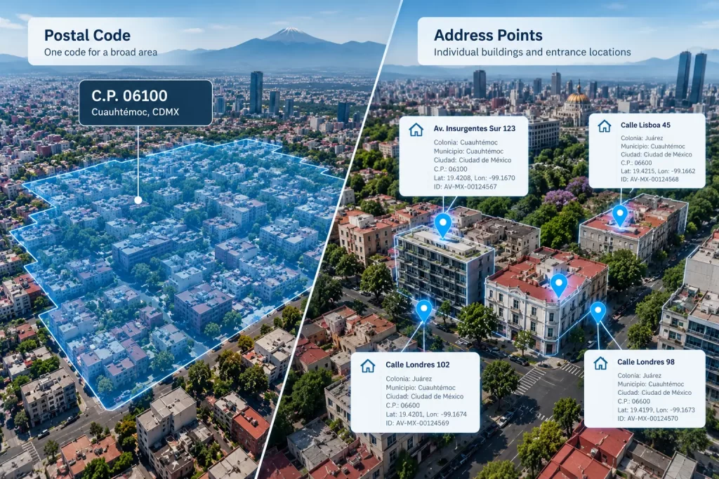
Buyers should therefore ask what the product actually contains rather than relying on the word “coverage.”
1. Measure completeness at the level your application needs
National coverage does not automatically mean that every addressable building, rural property, business, apartment or newly constructed premise is represented. Completeness should be evaluated by geography and record type.
A representative assessment should include:
- dense urban neighbourhoods;
- rapid-growth suburban areas;
- smaller municipalities and rural communities;
- industrial and commercial corridors;
- multi-unit buildings;
- areas where streets or settlements have alternate names.
Ask the provider to explain what counts as an address record, how non-addressable features are excluded and how known gaps are documented. A national total is useful context, but it is not a substitute for local validation.
2. Understand where the coordinate is placed
For many business uses, a valid address with a poor coordinate is still a poor result. A point placed on a road centreline may be adequate for regional visualization but unsuitable for final-mile navigation, entrance-aware routing or property-level risk analysis.
Useful positional classes may include building, primary entrance, parcel, access point, interpolated street location or broader geographic centroid. The provider should identify which classes are present and, ideally, supply a field that allows customers to filter or score them.
During evaluation, inspect points visually against current road and building context. Test whether coordinates fall on the intended side of the road, within the correct development and near a plausible access location. Do not assume that a coordinate with many decimal places is accurate.
3. Review address structure, not just a formatted label
A single display string is convenient for a map, but enterprise systems usually need structured components. At minimum, buyers should look for fields covering:
- exterior civic number and suffix;
- street name, type and directional elements;
- interior or unit information where available;
- settlement, neighbourhood or locality;
- municipality and state;
- postal code;
- latitude, longitude and coordinate reference system;
- source or lineage indicator;
- stable record identifier;
- quality or confidence class;
- version or effective date.
Mexico’s addressing conventions can include varied street naming, abbreviations, kilometre references, building identifiers and interior numbers. A good schema preserves important source information while also offering normalized fields for matching and integration.
4. Test consistency, duplicates and change management
Address databases change continuously. New developments appear, streets are renamed, civic numbers are corrected and postal assignments change. A static national file can become difficult to maintain if records lack stable identifiers or if each refresh is delivered as an unrelated snapshot.
Ask how the provider manages:
- duplicate addresses with different coordinates;
- multiple premises at one location;
- alternate spellings and accents;
- placeholder or incomplete street values;
- retired and replaced addresses;
- full-file versus incremental updates;
- record additions, deletions and corrections between versions.
For ongoing integration, a change file and persistent identifier can be as important as the initial national delivery.
5. Match the delivery format to the production environment
A GIS analyst may prefer GeoPackage or Shapefile for evaluation, while a cloud platform may require Parquet, CSV, GeoJSON or a database-ready export. High-volume address data can strain formats that were designed for smaller desktop projects, so file size, field limits, indexing and character encoding should be tested before procurement.
Confirm the coordinate reference system, text encoding, field definitions and null-value rules. If the data will support an API, ask whether the licence permits server-side search, geocoding, reverse geocoding, customer-facing display or derived outputs.
6. Read the licence in the context of the intended use
“Commercial use” is not one permission. Internal analysis, use across affiliates, customer-facing maps, SaaS products, redistribution, derived datasets and API responses can carry different rights.
Before purchase, document:
- who may access the data;
- whether contractors and affiliates are included;
- whether records or coordinates may appear in customer-facing products;
- which derived works may be retained or distributed;
- what happens when the subscription ends;
- whether evaluation samples carry different restrictions;
- which third-party attributions or source conditions apply.
Official reference datasets may also have their own use and attribution terms. A commercial provider should be able to explain the rights attached to the delivered product without implying endorsement by an official source.
A practical Mexico address-point evaluation
The most reliable procurement process begins with a representative sample and a written test plan. Select several areas that reflect the real deployment—not only a well-mapped central district. Provide a known set of addresses or operational cases, then measure:
- match rate;
- field completeness;
- coordinate precision;
- duplicate rate;
- street and locality normalization;
- postal-code consistency;
- unit handling;
- format and loading performance;
- licensing fit.
Record failures by category. A lower headline match rate with transparent, high-quality placement may be more useful than a higher result built on centroids or uncertain interpolation. The right threshold depends on the use case.
How Aeroview supports Mexico address-data evaluation
Aeroview supplies address-point and postal-boundary products for enterprise mapping, analytics and operational applications. Mexico datasets can be delivered in GIS and database-ready formats with licensing structured around the customer’s deployment requirements.
Before recommending a configuration, Aeroview works with buyers to identify the geography, schema, refresh cadence and permitted uses that matter to the project. Representative samples can be used to test coverage and integration before a national commitment.
Request a Mexico address-point sample, schema and licensing summary to evaluate the product against your routing, geocoding, analytics or platform requirements.
Contact Aeroview to request a representative Mexico sample, current technical specification and licence options for internal, platform or customer-facing use.
Frequently asked questions
Are Mexico postal codes the same as address points?
No. A postal code is a postal reference for an area or delivery designation. An address point represents a specific address or premise with coordinates.
What format should a Mexico address database use?
The best format depends on the workflow. GeoPackage and File Geodatabase are useful for GIS evaluation; CSV, Parquet and database exports often work better for large analytical or cloud environments.
How should buyers verify positional accuracy?
Test representative samples against current road, parcel, building and entrance context. Ask for a positional-quality class and do not infer accuracy from coordinate precision alone.
How often should Mexico address data be updated?
The appropriate cadence depends on the application and areas of interest. High-growth logistics, mapping or customer-onboarding systems may require more frequent updates than periodic analytical projects.