When buyers search for “UK postal code polygons,” they are usually looking for UK postcode boundary data they can actually use in production: for analytics, routing, service-area design, geocoding, logistics, territory planning, and customer intelligence. In the United Kingdom, postcode geography is deeply embedded in business operations because postcodes are familiar, operationally meaningful, and widely used as a reference layer across public and private datasets.
For most commercial teams, the issue is not whether postcode data exists. It is whether the data is available as usable polygons, licensed correctly, updated often enough, and packaged in formats that fit real workflows. That is where many projects slow down. Open datasets may provide postcode points or other supporting geographies, but commercially usable postcode boundary polygons are a different category of data product. Aeroview positions itself in that gap by supplying production-ready postal code polygon data for business use, with enterprise-oriented licensing and delivery options suited to mapping platforms, analytics stacks, and SaaS environments.
Why UK postcode polygons matter
A postcode point gives you a single coordinate. A postcode polygon gives you an area. That difference matters whenever the business question is territorial rather than address-specific.
If you are assigning leads to reps, designing delivery zones, measuring market penetration, modelling service coverage, or aggregating activity by postcode, polygons are usually more useful than centroid points. Ordnance Survey explicitly notes that polygon postcode data provides a more realistic representation of postcode coverage than point data and improves geotargeting, profiling, route optimisation, reverse geocoding, and operational planning. Aeroview likewise positions postal code polygons as a better fit for enterprise mapping, location analytics, segmentation, and service-area analysis than point-only approaches.
This matters in practice because postcode geography does not neatly align with administrative geographies such as wards or local authority boundaries. The Office for National Statistics notes that postcode boundaries often straddle other geographies, and that postcode allocations change continuously as new addresses are added, areas are recoded, and delivery structures evolve. For businesses, that means outdated or overly simplified postcode layers can quietly distort reporting, territory design, and operational decisions.
Common UK postcode geography levels
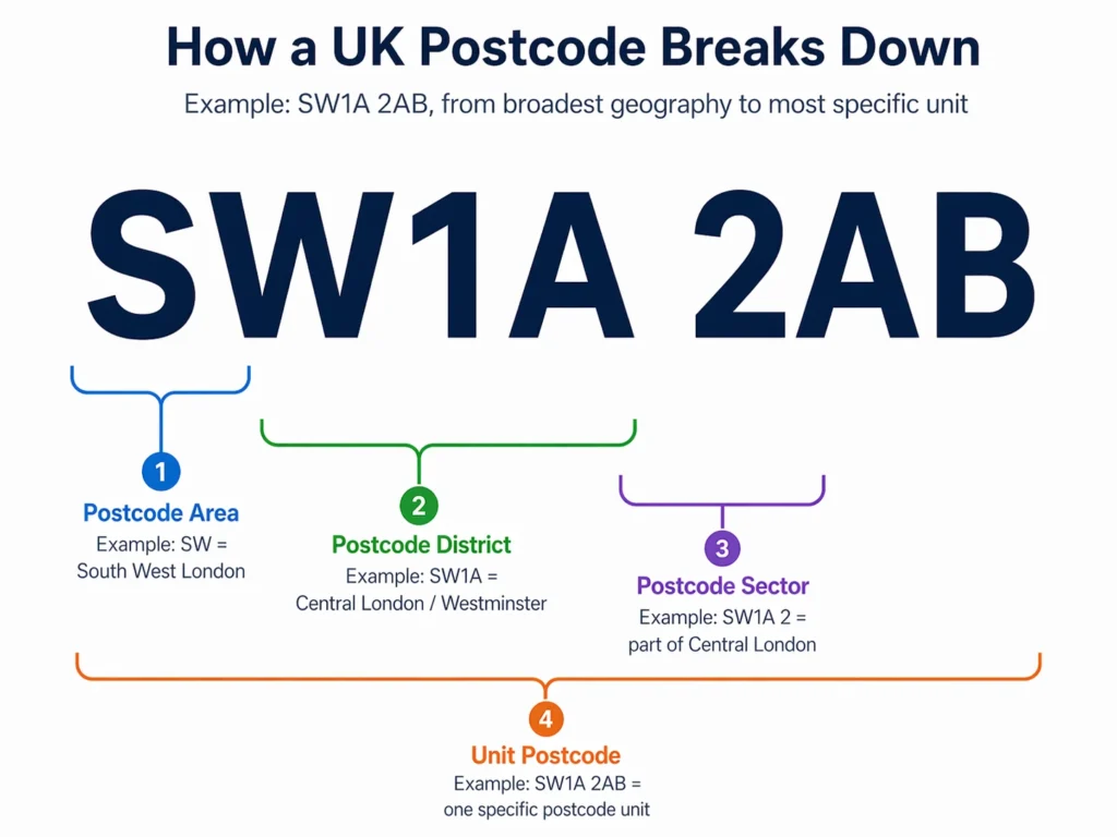
UK postcodes are hierarchical. For business users, that hierarchy is useful because different teams need different levels of aggregation.
The Office for National Statistics describes four main levels of postcode geography: postcode area, postcode district, postcode sector, and unit postcode. Using the example PO15 5RR, PO is the postcode area, PO15 the district, PO15 5 the sector, and PO15 5RR the unit postcode. ONS lists 124 postcode areas, 3,118 postcode districts, 12,463 postcode sectors, and approximately 1.79 million live unit postcodes in the UK as of August 2022.
For most business applications, these levels serve different purposes:
- Postcode areas are useful for executive reporting, broad regional comparisons, and high-level territory frameworks.
- Postcode districts are often a good middle ground for sales coverage, branch network planning, and regional performance dashboards where unit-level data would be too granular.
- Postcode sectors are commonly used for operational targeting, direct mail, local delivery planning, catchment analysis, and service design. Royal Mail’s own Door to Door guidance highlights postcode sectors as a practical targeting unit for campaign delivery.
- Unit postcodes are the most granular level and are the level most often associated with premium polygon datasets used in detailed routing, reverse geocoding, market intelligence, and fine-grained location analytics. Ordnance Survey’s Code-Point with Polygons product is built around unit postcode geometry for Great Britain.
What businesses use UK postcode polygons for
UK postcode polygons are not just a mapping layer. They are a decision layer.
In analytics and BI, they are used to aggregate revenue, leads, claims, deliveries, churn, incidents, or demand by postcode geography. In network planning, they help teams compare performance and coverage across postcode districts or sectors. In logistics and field operations, polygon boundaries are used to define service areas, optimise routing, assign jobs, and understand where operational responsibility begins and ends.
In customer and market analysis, postcode polygons are useful because many commercial datasets can be joined or approximated to postcode geographies. That supports retail catchment studies, insurance risk mapping, telecom rollout planning, franchise development, direct mail targeting, and sales territory design. Aeroview’s positioning around location analytics, market segmentation, mapping, routing, and enterprise integration fits these same operational and commercial use cases.
For software teams, postcode polygons also support application features such as postcode-based search, area shading, service-eligibility checks, and reverse lookup workflows. That is one reason delivery format matters. A business-grade dataset should be available in formats your stack can actually use, not just in a specialist GIS export. Aeroview offers postal polygon delivery options including API, WMTS, GeoJSON, Shapefile, and CSV.
Why open data is usually not enough
Some buyers assume they can start with an open UK postcode dataset and add boundaries later. Sometimes that is enough for a prototype. Often it is not enough for production.
That is why many business teams eventually move from “postcode points we can download” to “postcode polygons we can rely on.” The gap between those two becomes obvious as soon as the project reaches routing, territorial analytics, customer coverage mapping, or client-facing product features.
Licensing considerations: what buyers need to check
Licensing of postal code polygons is where postcode projects often become more complicated than expected.
For a buyer, that usually means five practical questions need clear answers before purchase:
- Can the data be used only internally, or also in client deliverables?
- Can it be embedded in a commercial product, platform, or SaaS workflow?
- Can it be published in web maps, reports, dashboards, or customer-facing applications?
- Does the licence cover redistribution, sublicensing, or downstream customer access?
- How often is the data refreshed, and what is the update path for production systems?
This is one of the strongest reasons to work with a supplier that understands commercial implementation, not just raw geography. Aeroview offers scalable licensing for internal business use, commercial applications, and SaaS platforms, along with regular refreshes and practical delivery formats. That is the language business buyers usually need, because the real problem is rarely “find a shapefile.” It is “get a legally usable, operationally practical dataset into production without creating risk.”
What to look for in a UK postcode polygon supplier
If you are evaluating UK postcode boundary data, focus on operational fitness, not just coverage claims.
The dataset should clearly state which geography levels are included, whether geometry is unit, sector, district, or area based, whether coverage is Great Britain or full UK, and how Northern Ireland is handled. It should also explain whether polygons are notional or aligned to buildings and land parcels, how often updates are issued, and which formats are available for GIS, analytics, and web delivery.
It is also worth checking whether the supplier can support the actual business workflow around the data: matching to address datasets, supporting reverse geocoding, integrating with internal systems, and accommodating commercial deployment models. Aeroview’s broad postal polygon offering is positioned around exactly those needs: mapping, location analytics, system integration, regular updates, and licensing for internal and commercial use.
Why businesses choose Aeroview for UK postcode polygons
Aeroview supplies UK postcode polygons as part of its global postal boundary portfolio, covering over 100 countries with production-ready data for analytics, logistics, and digital products.
For businesses researching geospatial data providers, Aeroview offers a more useful approach than a generic data download. The focus is on helping organisations access postcode boundary data they can actually use for analytics, logistics, software applications, service planning, and business intelligence.
Aeroview’s postcode polygon datasets are designed for organisations that need:
- commercially usable UK postcode boundary data
- support for business analytics and operational use
- geospatial data suitable for logistics and service-area applications
- practical delivery formats for integration into internal systems
- licensing options aligned with commercial business requirements
That makes Aeroview relevant for companies that need more than a reference layer. It makes Aeroview relevant for companies that need postcode geography to support decisions, workflows, and products.
Aeroview also provides verified rooftop address points and postal code polygons globally, so, organisations running multi-country operations can standardise on a single vendor for both UK and international coverage – with consistent schema, delivery methods, and support.
If you need to evaluate fit before committing, Aeroview offers sample postcode polygon shapefiles so your GIS and analytics teams can validate coverage, accuracy, and compatibility with their tools.
FAQ
What is the difference between a UK postcode point and a UK postcode polygon?
A postcode point is a single coordinate. A postcode polygon is an area boundary. Points are useful for simple lookup and geocoding, while polygons are typically better for territory analysis, service areas, routing, and aggregated reporting.
Does “UK postcode polygons” always include Northern Ireland?
No. Some postcode geometry products are Great Britain only. Some providers separate Great Britain and Northern Ireland postcode products, so UK-wide projects should confirm exactly what is included.
Why is licensing important for postcode polygon data?
Licensing determines how the data can be used. Businesses often need postcode polygons for internal systems, analytics, customer-facing applications, or commercial products, so the licence must match the intended use.
What should I look for in a UK postcode polygon provider?
Look for commercial usability, clear licensing, regular updates, practical delivery formats, and a provider that understands analytics, logistics, and operational applications.