“Global coverage” is one of the easiest claims to make in location data, and one of the hardest to evaluate.
A provider may count every country where it has a city list, postal reference table or geocoding result as covered. Another may reserve the word coverage for address-level records with coordinates. Both can describe themselves as global, even though the products support entirely different business decisions.
For organizations buying international address data, the useful question is not simply, “How many countries are included?” It is: “What can this product reliably do in each country today?”
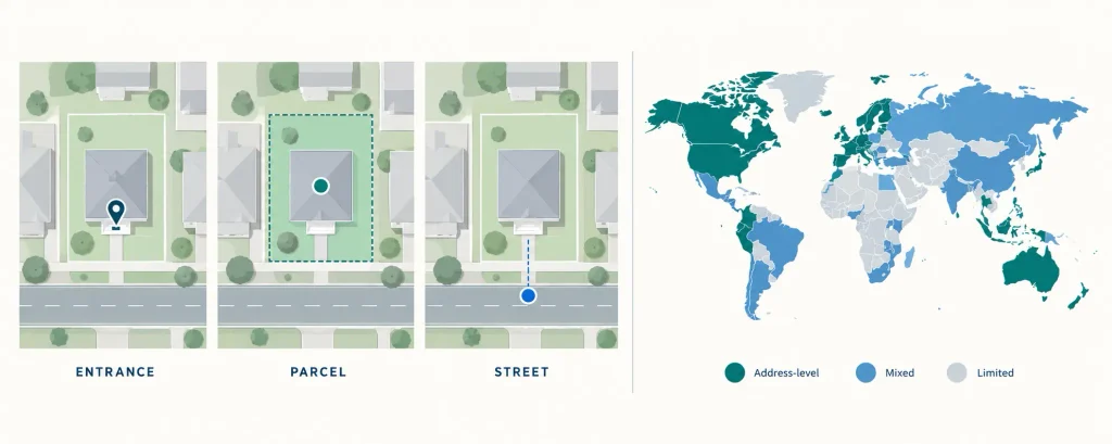
Global is not a single level of detail
Addressing systems developed locally. They reflect different languages, postal practices, government structures and conventions for streets, buildings and units. The Universal Postal Union notes that international addressing spans more than 200 address formats, roughly 200 database structures and at least 20 official writing scripts. A single normalized table can make these systems easier to use, but it cannot erase the underlying differences.
In one country, a record may identify a building entrance. In another, the most consistent national source may locate a property parcel, street segment or postal delivery point. Rural routes, post-office boxes, large-volume recipients and informal settlements introduce additional exceptions.
A credible international supplier should preserve those distinctions. Standardization is valuable; pretending every country has identical address precision is not.
Coverage should be measured country by country
A useful coverage matrix should show more than a checkmark beside a country name. At minimum, it should identify:
- the geographic level represented;
- the approximate number of current records;
- the effective or source date;
- whether coordinates are building-, parcel-, entrance-, street- or locality-level;
- known geographic or address-type exclusions;
- available update frequency; and
- delivery formats and licensing conditions.
This matters because national totals can hide regional gaps. A dataset may perform well in major cities but have weaker rural coverage. Another may include nearly every address but use mixed positional methods. Those products may still be valuable, but they should be evaluated against the intended workflow rather than one headline number.
Currency is a production process, not a label
Address information changes continuously. New subdivisions are built, streets are renamed, municipalities reorganize records, postal assignments change and multi-unit buildings are added or corrected.
“Updated regularly” is therefore not enough. Buyers should ask when each country was last refreshed, how changes are detected, which quality checks occur before release and whether updates include version identifiers or change files.
The appropriate cadence depends on the application. A long-range market study may tolerate annual updates. Address validation, last-mile delivery, network planning and customer-facing location services may require quarterly or monthly maintenance. The supplier should be able to explain the trade-off instead of applying one schedule to every country.
Points, addresses and validation services are different products
An international address database can refer to several things:
- a normalized list of address components;
- geocoded address points;
- a validation or autocomplete service;
- street ranges used for interpolation;
- building, parcel or entrance locations; or
- a combination of these resources.
Before comparing vendors, define the operation the system must perform. Does it need to verify that an address is deliverable? Place a marker on a map? Route a driver to an entrance? Assign properties to risk zones? Enrich millions of existing records?
The same product will not be best for every task. A validation service may be ideal for customer checkout but unsuitable for bulk spatial analysis. A rooftop point layer may support risk and network modelling but may not confirm postal deliverability. The evaluation should test the actual operation.
Normalization should preserve local meaning
Multi-country data needs consistent fields for engineering and analytics: country code, locality, postal code, street, civic number, unit and coordinates. But local information should not be forced into a model that loses meaning.
Strong schemas combine normalized fields with original-language values, source identifiers, administrative context and quality indicators. They also document how missing components, abbreviations, diacritics and multiple scripts are handled.
The goal is not to make every address look North American. It is to make different address systems usable together without disguising the differences that affect quality.
Licensing can determine whether the product works
Technical fit is only half the decision. International products often combine sources with different rights and restrictions. Buyers should confirm whether the licence permits internal analytics, customer-facing applications, address validation, derived products, API responses, affiliates, contractors and long-term retention.
A sample may be technically excellent and still be unusable if the production licence excludes the intended deployment. Resolve licensing before a proof of concept consumes engineering time.
How to run a useful international evaluation
Start with representative countries, not the easiest ones. Include a dense urban market, a rural or remote area and a country with a different language or postal structure. Test real workflows and measure:
- coverage against known addresses;
- duplicate and missing records;
- coordinate precision and outliers;
- schema consistency;
- load and query performance;
- clarity of version and source metadata; and
- the effort required to process an update.
Record the product version and evaluation date. Without them, results cannot be reproduced and improvements cannot be measured.
Global coverage should become more useful over time
The strongest international suppliers do more than assemble a large static file. They maintain country-level production processes, document changes, improve coverage and deliver updates in a form clients can integrate repeatedly.
That is the standard global buyers should demand: not a map filled with country colours, but current, explainable coverage that supports real decisions in each market.
Aeroview develops and maintains address, postal, parcel and boundary datasets for organizations operating across multiple countries. To compare coverage for a specific market or evaluate representative data, request a country review and sample.