Introduction: Why Address Points Matter for Your Business
In an era where location accuracy can make or break business decisions, understanding address points has become essential for organizations across industries. Could be that you’re underwriting insurance policies, optimizing delivery routes, or conducting emergency response planning, the precision of your location data directly impacts your bottom line – with poor data quality costing businesses an average of $12.9 million annually (according to Gartner).
Address points represent the most precise form of location intelligence available, combining verified postal addresses with exact geographic coordinates to pinpoint specific structures on Earth’s surface. Unlike traditional geocoding methods that approximate locations, modern address point databases with rooftop-level accuracy and monthly refresh cycles provide the foundation for confident decision-making in real estate, insurance, logistics, and public safety operations.
What Are Address Points? The Foundation of Location Intelligence
Address points are spatial data records that combine a complete postal address with precise geographic coordinates (latitude and longitude) to identify the exact location of a site or structure. Each address point consists of two essential components: the address string (including number, street name, city, state, and postal code) and spatial coordinates that give the address a physical location on a map in a GIS environment.
Core Components of Address Points
Every address point contains standardized information that makes it valuable for business applications:
Address String Elements: Street number, street name with directionals and type, unit/suite information for multi-occupancy buildings, city or municipality name, state or province, and postal or ZIP code.
Geographic Coordinates: Latitude and longitude in decimal degrees, coordinate reference system (typically WGS84 or NAD83), and precision level indicator (rooftop, parcel, street, or ZIP centroid).
Metadata and Quality Indicators: Source of the address data, last verification or update date, confidence score or accuracy rating, and unique persistent identifiers for data linking.
Unlike simple address lists or interpolated street geocodes, address points are created through systematic processes that match authoritative postal records with surveyed or imagery-derived building locations. This approach ensures each point represents an actual deliverable location rather than an estimated position along a street segment.
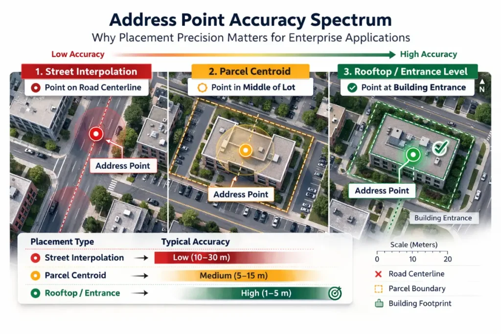
The Rooftop Advantage: Why Precision Matters
Rooftop geocoding represents the gold standard in address point accuracy, placing coordinates directly on the primary structure of a property rather than approximating location through parcel centroids or street segments. The distinction between rooftop-level and alternative geocoding methods has profound implications for risk assessment, operational efficiency, and regulatory compliance.
Understanding Geocoding Precision Levels
Different geocoding methodologies produce varying levels of accuracy:
Rooftop-Level Geocoding: Places coordinates on the actual building footprint, typically at the center of the primary structure. Accuracy within 1-5 meters of the actual building location. Essential for applications requiring proximity measurements to specific hazards or features.
Parcel Centroid Geocoding: Identifies the center point of the property parcel or lot boundary. Can be 50-300+ feet from the actual structure on large or irregular properties. May cause significant errors in multi-building properties or rural areas.
Street Segment Interpolation: Estimates location based on address ranges along street centerlines. Accuracy ranges from 20-200 meters depending on block size and address distribution. Cannot distinguish between structures on the same street segment.
ZIP Code Centroid: Uses the geographic center of postal code boundaries. Accuracy measured in miles rather than feet. Suitable only for broad demographic analysis, not individual property assessment.
Research has demonstrated that in high-stakes applications like property insurance, the difference between rooftop and parcel-level geocoding can result in premium pricing errors ranging from 5% to 87%, translating to thousands of dollars per policy in mispriced risk.
Real-World Impact of Rooftop Accuracy
The precision advantage of rooftop geocoding delivers measurable benefits across industries:
Insurance Risk Assessment: Accurate measurement of distance to flood zones, wildfire fuel loads, and coastal erosion risks. Proper identification of structures within or outside high-risk territories. Reduced exposure to underpriced policies that can cost insurers millions annually.
Emergency Response: 911 systems using rooftop-accurate address points can direct first responders to exact building locations, reducing response times by directing resources to the correct structure in multi-building campuses. Enhanced location validation for indoor mapping and subaddress routing.
Logistics and Last-Mile Delivery: Precise drop-off locations for high-value packages and time-sensitive deliveries. Route optimization based on actual building positions rather than street centerlines. Reduction in delivery failures and associated costs ($5 per undelivered package adds up quickly).
Real Estate and Property Assessment: Accurate property valuations based on true building locations and proximity to amenities. Site selection analysis using precise distance measurements. Improved property boundary determination and land use planning.
Verified Address Points: Quality You Can Trust
Address verification transforms raw location data into authoritative, standardized records that meet postal service requirements and ensure deliverability. The verification process validates address existence, corrects formatting inconsistencies, standardizes components according to postal authority guidelines, and appends additional intelligence like delivery point validation codes.
The Verification Process Explained
Professional address verification follows a systematic approach:
Parsing and Standardization: Breaking addresses into component parts (street number, name, type, directionals). Correcting abbreviations and common misspellings. Standardizing formats according to USPS or international postal standards.
Validation Against Authoritative Sources: Cross-referencing against postal service databases (USPS, Canada Post, international authorities). Confirming delivery point validation (DPV) status. Identifying residential vs. commercial properties.
Quality Enhancement: Adding missing components (ZIP+4 codes, suite numbers). Flagging vacant properties and non-deliverable addresses. Appending carrier route codes and sort sequence data.
Change Detection and Maintenance: Identifying moved addresses through NCOA (National Change of Address) processing. Detecting new construction and address assignments. Updating records as postal authorities modify boundaries and assignments.
Studies show that proper address verification can improve delivery success rates by 62% while cutting undeliverable mail costs by up to $223,200 annually for medium-sized operations. For healthcare organizations alone, incorrect addresses contribute to $6 billion in denied claims annually, with 35% of claim denials resulting from patient identification errors including faulty address information.
CASS Certification and Postal Standards
In the United States, CASS (Coding Accuracy Support System) certification ensures that address verification software meets USPS accuracy standards. CASS-certified solutions provide access to critical postal tools including RDI (Residential Delivery Indicator), SuiteLink for business address enhancement, LACSLink for rural route conversions, and DPV confirmation for deliverable addresses.
International address verification requires similar attention to local postal standards, with each country maintaining its own formatting rules and validation requirements. Professional verification platforms support 245+ countries with localized validation logic.
Monthly Refresh Cycles: Keeping Data Current
The value of address point data degrades rapidly without regular updates, as communities continuously evolve through new construction, demolitions, street renamings, and postal code reassignments. Leading address data providers have transitioned to monthly refresh cycles to ensure customers access the most current information available.
Why Refresh Frequency Matters
The address landscape changes constantly:
New Construction: Thousands of new residential and commercial structures receive address assignments daily. Properties under development transition from permitted to occupiable status. Multi-unit buildings add or modify unit designations as occupancy changes.
Infrastructure Changes: Municipal governments rename streets, adjust numbering systems, and modify postal boundaries. Rural areas convert from route-based to street-based addressing. Emergency service boundaries shift, affecting 911 routing and response.
Postal Authority Updates: ZIP codes and postal codes receive regular boundary adjustments. Carrier routes reorganize as delivery patterns change. USPS identifies new vacant properties and non-deliverable locations.
Demographic and Economic Shifts: Neighborhoods gentrify or decline, changing risk profiles. Commercial properties convert to residential use or vice versa. Address volumes in growing areas can increase by millions per quarter.
Providers like Loqate, which transitioned to monthly data updates in November 2023, guarantee that the most recent data from their suppliers integrates into their products within a 30-day timeframe. In Q4 2023 alone, this resulted in adding 17.9 million new premises to their database, with 7 million additional premises in Mexico.
Return on Investment for Current Data
Organizations that prioritize data freshness report significant competitive advantages:
Reduced Operational Costs: Fewer returned deliveries and reshipments. Lower manual cleanup and correction efforts. Decreased customer service inquiries about delivery failures.
Improved Customer Experience: Timely communications reach intended recipients. Orders arrive as expected, building trust and loyalty. Reduced frustration from address-related issues.
Enhanced Decision-Making: Risk models reflect current property conditions. Market analysis incorporates latest development patterns. Compliance reporting uses accurate exposure data.
Competitive Differentiation: Faster response to market opportunities. More accurate pricing and quoting. Better resource allocation based on current geography.
For direct mail campaigns specifically, address verification with current data can improve ROI dramatically, with verified addresses generating an average return of $12.57 in sales for every dollar spent on direct marketing – a 40% boost in delivery accuracy compared to unverified lists.
Address Points Around the World: Regional Considerations
While the fundamental concept of address points remains consistent globally, implementation details vary significantly by country and region. Understanding these regional nuances ensures successful international operations.
Canada: Precision in the Great White North
Canada’s address point ecosystem combines rigorous postal standards with unique geographic challenges posed by vast rural areas and bilingual requirements. The Canadian postal code system uses a six-character alphanumeric format (e.g., M5V 3L9) that provides more granular geographic precision than U.S. ZIP codes.
Key Characteristics: Forward Sortation Area (FSA) comprises the first three characters, identifying broad regions. Local Delivery Unit (LDU) comprises the last three characters, narrowing to specific blocks or buildings. In urban cores, 87.1% of postal codes match to a single dissemination area, enabling precise geocoding. Rural areas present challenges, with only 26.2% to 38.1% matching to single dissemination areas.
Data Sources and Standards: Canada Post maintains authoritative postal code files and address databases. Verified rooftop geocode data creates boundaries for postal code polygons. Provincial and municipal GIS programs contribute additional address point datasets. Coverage continues to expand, though some rural areas have limited data points.
Business Applications: Property insurance underwriting with accurate risk assessment. Direct mail campaigns requiring bilingual address formatting. Real estate market analysis at the neighborhood level. Logistics optimization accounting for vast distances and sparse rural populations.
Formatting Considerations: Postal codes require proper spacing (M5V 3L9, not M5V3L9). Addresses may appear in English or French depending on region. Province abbreviations follow standardized two-letter codes. Similar-looking characters (O vs. 0, I vs. 1) require careful validation.
Mexico: Navigating Colonia and Código Postal
Mexican address structures differ significantly from North American conventions, incorporating neighborhood designations (colonias) and unique hierarchical addressing that requires specialized validation logic. The Mexican postal service, Correos de México, maintains the authoritative Código Postal system of five-digit postal codes.
Address Components: Street name and number (often including interior and exterior building numbers). Colonia (neighborhood) or Fraccionamiento (housing development), abbreviated as Col. or Frac. Código Postal (five digits), city, and state abbreviation. Country name in capital letters for international mail.
Data Availability: Major providers added significant Mexican premise-level data in recent years. Loqate added 7 million additional premises in Mexico in Q4 2023. Coverage strongest in major metropolitan areas, with ongoing expansion to rural regions. Sources include INEGI (National Institute of Statistics and Geography) and private data aggregators.
Unique Challenges: Multiple address formats exist for residential, business, rural, and P.O. box addresses. Dependent localities create complex hierarchical relationships. Interior/exterior number distinctions require specialized parsing. Accents and special characters in Spanish names affect validation.
Validation Best Practices: Verify complete address hierarchies including Colonia designations. Standardize abbreviations for address types (Calle, Avenida, etc.). Confirm Código Postal matches municipality and state. Account for addresses in villages (pueblos) with different formatting rules.
Brazil: Addresses in Latin America’s Largest Economy
Brazil’s addressing system reflects Portuguese linguistic conventions and a federal structure of states and municipalities, requiring careful attention to formatting and regional variations. The Brazilian postal service, Correios, administers an eight-digit postal code system (CEP – Código de Endereçamento Postal) with enhanced granularity.
Address Format: Recipient name. Street type (Rua, Avenida, etc.) and name with building number. Unit or apartment number using “/” separator (e.g., “517 / 205”). Neighborhood and municipality name. State abbreviation (two letters). Eight-digit CEP (formatted as 12345-678 or 12345678).
Geographic and Administrative Structure: Brazil comprises 26 states plus the Federal District (Distrito Federal). States divided into municipalities (municípios) with varying address conventions. Major cities like São Paulo and Rio de Janeiro have complex urban addressing. Rural areas use different formats, sometimes referencing landmarks.
Data Characteristics: Premise-level data availability varies significantly by region. Major urban centers have comprehensive address point coverage. Favelas and informal settlements present unique challenges for standardization. New developments receive address assignments at varying rates.
Practical Considerations: Address verification APIs support 245+ countries including comprehensive Brazil coverage. CEP format requires hyphen in formal addresses but may appear without in databases. State abbreviations are critical for disambiguation (multiple cities share names across states). Commercial addresses often include business names as location identifiers.
Italy: Historical Streets Meet Modern Geocoding
Italian address structures combine centuries-old street naming traditions with modern postal codes (CAP – Codice di Avviamento Postale), creating unique verification requirements. The Italian postal service, Poste Italiane, maintains the authoritative addressing database alongside national mapping agencies.
Address Components and Format: Recipient name and optional business/department name. Street type (Via, Corso, Piazza, etc.) and name followed by building number. Five-digit CAP (Codice di Avviamento Postale), city name, and province code (two letters). Country name “ITALY” in capital letters for international correspondence.
Regional Considerations: German language addresses common in South Tyrol (Alto Adige) region. Historic city centers have complex street patterns requiring precise geocoding. Rural areas and small towns may have less granular postal codes. Province codes critical for disambiguation of common city names.
Data Sources: National mapping authorities provide authoritative address point datasets. Geocoding services leverage multiple data sources including government databases. Both government and commercial providers offer Italian address validation. Coverage includes premise-level data for most populated areas.
Geocoding Characteristics: Geocoding attempts to reach street address level precision. Some matches may fall to postal code centroid when structure data unavailable. Urban areas generally have better rooftop-level coverage. German thoroughfare types and abbreviations supported in bilingual regions.
Validation Requirements: Addresses must contain either city or postal code (preferably both). Street type abbreviations standardized (e.g., Via, V., Viale, V.le). Postal codes follow five-digit numeric format (e.g., 00144, 52036). Province abbreviations use official two-letter codes (e.g., NA for Naples, AR for Arezzo).
Industry Applications: Where Address Points Drive Value
The precision and reliability of verified, rooftop-accurate address points with monthly refresh cycles create competitive advantages across numerous industries. Organizations that invest in quality location data consistently outperform competitors relying on approximated or outdated information.
Property & Casualty Insurance
Insurance companies represent one of the most demanding users of address point data, where location accuracy directly impacts profitability through risk assessment, premium pricing, and claims management.
Underwriting and Risk Assessment: Rooftop geocoding enables precise measurement of distance to wildfire fuel loads, flood zones, coastal erosion areas, earthquake fault lines, and other hazard zones. Studies show that parcel-centroid geocoding can lead to premium pricing errors as high as 87% on some policies, translating to $2,800 per year per policy in mispriced risk. Location analytics reduces fraudulent claims by nearly 20% through verification of claimed incident locations. Enhanced risk differentiation ensures properties in the same postal code receive appropriate pricing based on actual risk profiles.
Claims Processing and Disaster Response: Satellite imagery and drone-based damage assessment requires accurate building locations. Rooftop geocodes accelerate claims processing after natural disasters. Verification of claimed loss locations against insured property coordinates detects inconsistencies. Real-time mapping with address points supports rapid response and adjuster deployment.
Regulatory Compliance: Accurate exposure reporting to state regulators and rating bureaus. Proper treatment of customers based on actual risk, meeting fair pricing requirements. Defensible methodology for risk-based pricing under regulatory scrutiny. Compliance with market conduct expectations for underwriting accuracy.
Logistics and Last-Mile Delivery
Delivery operations depend on precise address points to optimize routes, reduce failed deliveries, and improve customer satisfaction.
Route Optimization: True building locations enable more efficient routing than street centerline approximations. Multi-stop route planning accounts for actual pickup and drop-off points. Dynamic routing adjusts for real-time traffic using precise destination coordinates. Delivery time windows become more accurate with precise location data.
Delivery Success and Cost Reduction: Verified addresses improve delivery success rates by 62%. Each undelivered package costs an average of $5 in lost postage and handling. Medium-sized operations save up to $223,200 annually through proper verification. Customer satisfaction improves as packages consistently reach correct locations.
Service Expansion and Market Analysis: Geocoded customer databases identify high-density service areas. Analysis reveals underserved markets for strategic expansion. Precise service area definitions enable accurate coverage commitments. Address points support geofencing for delivery notifications and tracking.
Real Estate and Property Development
Real estate professionals use address point data for property valuation, market analysis, and site selection decisions.
Property Valuation and Assessment: Accurate building locations ensure proper comparable property analysis. Proximity measurements to schools, parks, transportation, and amenities affect valuations. Property tax assessments rely on correct parcel-to-address matching. Investment decisions depend on precise location relative to development trends.
Market Intelligence: Geocoded transaction data reveals neighborhood-level price trends. Spatial analysis identifies emerging investment opportunities. Development feasibility studies incorporate precise existing building inventories. Competitive property analysis requires accurate location comparisons.
Marketing and Client Services: Professional digital and printed marketing materials use accurate property mapping. 3D renderings and virtual walkthroughs depend on correct building positions. Mobile apps for property search require precise geocoding. Hyperlocal neighborhood insights win business with discerning clients.
Emergency Services and Public Safety
911 systems and emergency response operations represent life-or-death applications of address point accuracy.
Next Generation 911 (NG911): Geographic Information Systems (GIS) evaluate spatial data to route calls to appropriate PSAPs. Enhanced location accuracy pinpoints callers in moving vehicles or remote areas. Indoor mapping with site/structure address points includes building names, floor numbers, and unit designations. Real-time mapping gives dispatchers instant access to detailed location information.
First Responder Coordination: Address points reduce response times by directing resources to correct structures in multi-building campuses. Subaddress information (floor, wing, unit) enables rapid location of specific apartments or offices. Pre-incident planning uses accurate building locations for facility layouts. Mutual aid coordination improves when jurisdictions share standardized address points.
Public Safety Infrastructure: Resilient emergency systems withstand natural disasters and public health emergencies. Continuous data improvement ensures system effectiveness during crises. Community well-being increases with faster, more accurate emergency response. Investment in NG911 with quality address points enhances overall safety infrastructure.
Healthcare and Patient Communication
Healthcare organizations face strict regulatory requirements and high costs from address-related errors.
Patient Record Accuracy: Incorrect addresses contribute to 35% of denied claims in U.S. healthcare. Over $6 billion lost annually from faulty patient identification including address errors. HIPAA compliance risks from communications sent to wrong addresses. Real-time verification prevents invalid addresses from entering systems.
Care Coordination and Communication: Pre-surgery instructions, appointment reminders, and lab results must reach patients reliably. Missed communications delay treatment and worsen patient outcomes. Billing accuracy depends on correct addresses for invoices and statements. Updated addresses through change-of-address processing maintain contact with mobile populations.
Operational Efficiency: Address verification ROI includes reduced postage waste, faster payment cycles, and lower labor costs. Point-of-entry validation eliminates costly back-end data cleanup. Geographic analysis of patient populations supports facility planning. Geocoded patient data enables disease surveillance and community health assessment.
Implementing Address Points: Best Practices for Success
Successfully leveraging address point data requires thoughtful implementation that balances accuracy requirements, cost considerations, and operational integration.
Selecting the Right Data Provider
Evaluate Accuracy and Precision: Verify rooftop vs. parcel centroid geocoding definitions – many providers mislabel parcel-centroid as “rooftop.” Test accuracy on challenging properties: farms, large commercial complexes, irregular lots, multi-building campuses. Request sample data for your specific geographic areas of interest. Compare match rates and precision codes across providers.
Assess Coverage and Freshness: Confirm premise-level coverage for your operational regions. Understand update frequency (monthly refresh cycles recommended). Inquire about sources: postal authorities, municipal GIS, imagery analysis, field surveys. Verify coverage of new construction areas critical to your business.
Consider Integration Options: API access for real-time validation at point of data entry. Batch processing for existing database cleansing. SDK availability for embedded applications. File download options for internal processing and analysis.
Review Pricing Models: Per-transaction pricing for variable volumes. Subscription tiers for predictable usage levels. Unlimited plans for high-volume operations. Custom enterprise agreements for complex requirements.
Data Integration Strategies
Point-of-Entry Validation: Implement autocomplete functionality to guide users toward valid addresses. Validate addresses in real-time as users submit forms or enter data. Provide suggestions when partial or incorrect addresses entered. Prevent invalid addresses from entering systems at the source.
Batch Database Cleansing: Schedule regular verification runs against existing address databases. Implement change-of-address processing (NCOA) on appropriate cycles. Flag records requiring manual review or customer contact. Track verification dates and confidence scores for audit purposes.
Geocoding Integration: Append coordinates during verification process or as separate enrichment step. Store precision indicators (rooftop, parcel, street, ZIP) with geocodes. Implement cascading logic: attempt rooftop first, fall back to less precise levels only when necessary. Document geocoding methodology for compliance and quality assurance.
Persistent Identifiers: Assign unique IDs during geo-addressing process for seamless data linking. Connect address records to enrichment datasets without manual mapping. Link addresses across systems using common identifiers. Enable efficient joining with demographic, risk, and property attribute data.
Quality Monitoring and Maintenance
Establish Data Quality Metrics: Monitor match rates and precision distribution over time. Track validation failure patterns to identify systemic issues. Measure downstream impacts: delivery success rates, claim accuracy, response times. Set thresholds that trigger investigation and remediation.
Implement Governance Frameworks: Define policies and procedures for address data management. Assign roles and responsibilities for data quality. Create standard operating procedures for verification and geocoding. Document escalation paths for quality issues.
Conduct Regular Audits: Perform periodic sample testing of address accuracy. Validate geocode precision against known ground truth. Review provider performance against service level agreements. Assess effectiveness of verification rules and business logic.
Continuous Improvement: Solicit feedback from users encountering address issues. Analyze failed validations to refine acceptance criteria. Test new data sources and validation methods. Stay current with provider enhancements and postal authority changes.
Conclusion: The Strategic Value of Address Points
Address points represent far more than technical geographic data – they constitute strategic assets that drive operational efficiency, competitive advantage, and regulatory compliance across industries. Organizations that invest in verified, rooftop-accurate address points with monthly refresh cycles consistently outperform competitors relying on approximated or outdated location information.
The business case for address point precision is compelling: insurance companies avoid millions in mispriced policies, logistics operations save thousands per month in delivery failures, healthcare organizations prevent billions in denied claims, and emergency services save lives with faster, more accurate response. The cost of poor data quality – averaging $12.9 million annually per organization – makes investment in quality address data an obvious strategic priority.
As location intelligence continues to evolve, address points will become increasingly central to artificial intelligence and machine learning applications, autonomous vehicle navigation, indoor positioning systems, and real-time population analytics. Organizations that establish robust address data foundations today position themselves to capitalize on these emerging opportunities tomorrow.
The question for business leaders is not whether to invest in quality address points, but rather how quickly they can implement systems that turn location data from a cost center into a competitive advantage. With monthly-updated, rooftop-verified address points accessible through modern APIs and data platforms, the tools exist today to transform location intelligence from a technical requirement into a strategic differentiator.